
| Darin McQuoid | Blog | Reviews | Tutorials | River Directory |
Middle
Cherry
"Cherry in the Middle"
V-V+
"Cherry in the Middle"
V-V+
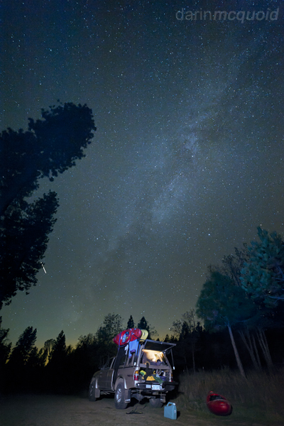
I'm proud of that fact that I have not spent an unplanned night on the river. This is due to being generally conservative about situations that may lead to a long cold night with no gear. The beta was that Middle Cherry is supposed to take about five hours and change. With a ten o'clock meeting at take-out and a hour plus shuttle, we should be starting the hike some time after eleven. That gives us a thin margin of error. It's October thirty-first and gets dark at five-thirty. We camp near take-out, so being there at ten is no problem. Unfortunately the Sacramento contingent of our group has run into traffic and will be a little late. A little late turns into an hour late. Car problems turn that hour into nearly two. It's noon and we're loading the kayaking gear into one car. I'm having second thoughts. We are already way behind schedule. It froze last night at lower elevations. I'd at least like to know where put-in is, soup the road we go. We're on the right track all the way until passing Cherry Lake. Then our veterans are not quite sure which road to take. We take a turn to the right and end up in an open patch with a view of Middle Cherry Creek, a tributary of the Tuolumne River, dropping out of Cherry Lake. We're still too high up, and retrace our steps to the main road. A few miles further down and we're on the right track again.
It's now one in the afternoon. Four and a half hours to dark. The run has a steep, cross country hike in through thick underbrush. Then four miles of V and V+ with a crux, forty foot waterfall in the middle. There is no perfect line on this one, contact with rock seems to be unavoidable. The portage takes over an hour itself and involves tricky rope work. There won't be time for that today. I'm out, I'll come back another day to see the beauty of the canyon. Then another team member is out. It's down to just two. A good number for going fast, but not for safety. They still want to put on. Knowing that situations like these often lead to epic stories, I decide to put on anyways.
We quickly don much of our kayaking gear, shoving the rest into kayaks and start hiking. It's steep and slippery. We traverse a lot to find clear paths. It's hot out, amazingly so for Halloween. We're all sweating. The hillside is steep, every step is a struggle against slipping and losing control. With the time constraint we have to push that limit and hike as quickly as possible. We stay close together so no one gets lost in the thick brush. Thankfully Thomas Moore has been here a few times before and has a general idea of where to go. Too close to Elanor Creek and we get cliffed out. Too far up Cherry Creek and we get cliffed out. There is a fine line right down the center that should allow us to reach the confluence and only lower our boats by rope one time. An hour after leaving the car we're on the right track and reach river level. No time is wasted putting our gear on. It's beautiful down here, but we need to keep moving ahead of impending darkness. Thomas leads the way, with an amazing memory for the complex and blind boulder gardens. It's steep and photogenic, curved white granite walls surround us. There is no time to get out and take picture of this beauty. Five or six rapids in and we make a quick portage. A dangerous rapid ends in a small pool above a whirlpool. An excessivly large chock stone blocks all the flow, the river siphons underneath. A whirlpool in the middle of the river; a sight to behold. We hurriedly walk down the left bank and seal launch in.
Rapid after rapid is knocked down, each challenging and complex. Suddenly we are in another big, blind boulder garden. Thomas tries to go left and gets hung up on a rock; I go to the right, only to eddy out above several dead ends. He moves far left and vanishes from sight. Taylor Cavin follows while I surf across a hole, attaining upstream to reach the left channel. Taylor looks back and yells "first descent" because Thomas just told him that he's always portaged this one before. Thankfully we're past the worst section and it's easy going to a pool at the bottom. A few more big boulder gardens with a fun slide or two mixed in leave me wishing for more time to take photographs, but that's not today's mission.
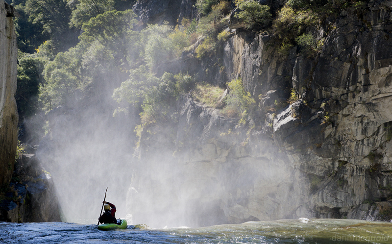
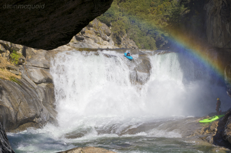
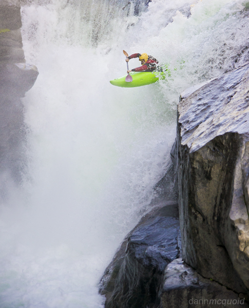
Out the left bank it's obvious that something happens downstream. We make a quick portage around a tough rapid that's been run a few times and paddle right to scout Freebird, the largest falls of the run. Freebird is an odd fortyish foot sliding waterfall. There isn't any truly bad line, neither is there a perfect line. Contact with a rock shelf is unavoidable, it's just a question of how one wants to tackle the issue. It's been portaged but we'd be out of daylight by the end of the long and complex affair. It's also photogenic, so I coerce Taylor into going first so I can shoot from above.
Taylor Cavin feelin the
Freebird.
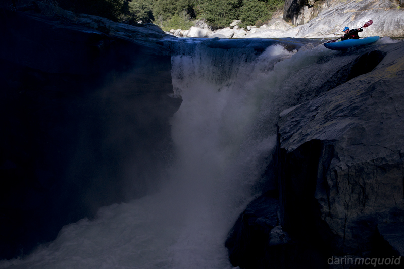
From above I can't see Taylors line. He signals Thomas to send me off a little bit more left. Sure thing. On this horizon I can't see anything to line up from. Well it looks like I'm about a foot more left then where I'd seen Taylor go off. I paddle over the lip and take a small stroke so I don't go all the way to vertical. Quick acceleration and a bump from the right then from the left and I resurface out the bottom. Not too bad. I hurry downstream and scramble out so I can get a shot from below.
Thomas Moore heads for
the center line
on Freebird.
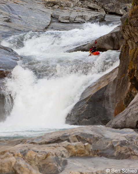
Boogie boogie boogie. We make quick time downstream due to Thomas's knowledge of the run, and then make a quick scout of Crazy Train.
The light is fading fast as Thomas gets into the Crazy Train.
Taylor Cavin boofs into one of the softest landings available.
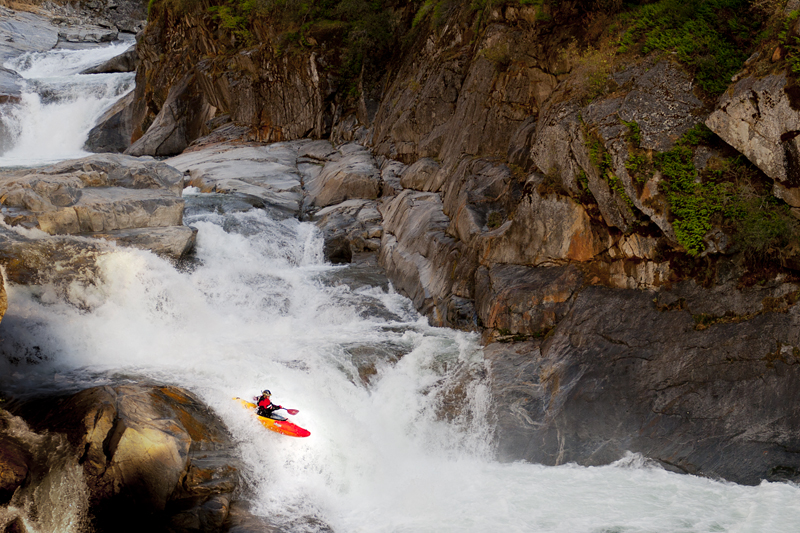
One amazing section, slide to slide on Middle Cherry.
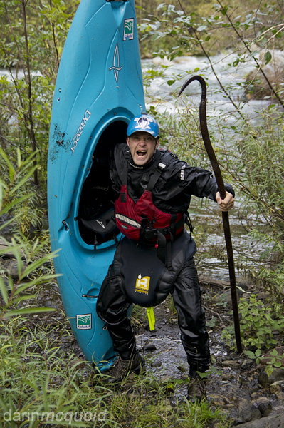
Somehow fitting for Halloween, Thomas Moore and the hook.
Boogie boogie boogie. We make quick time downstream due to Thomas's knowledge of the run, and then make a quick scout of Crazy Train.
The light is fading fast as Thomas gets into the Crazy Train.
Taylor Cavin boofs into one of the softest landings available.
We
celebrate briefly and
head downstream chasing fading light. The
gradient has eased up but the rapids are still tough. Somewhere in here
we make one more portage on the right, then cruise down and see a man
made structure on the left. There is an old diversion dam and a trail
if need be. There is still enough light for us to finish the run
without too much of a hurry. Thomas and Taylor fill me in on the
necessary beta for one of the largest drops of the run. The slide is
very unique and super fun to bomb into.
One amazing section, slide to slide on Middle Cherry.
The two
clean slides are an
abnormality. The river returns to boulder gardens, a few of the not so
clean variety. In a few minutes the bridge comes into view and we slide
into an eddy beneath it. The run is over and I'm relieved to be done
before dark, with forty five minutes to spare. Not much margin for
error, but we know that dropping in. We celebrate in the parking lot,
pack our gear and head back to real life, glad to have had a blissful
escape from an extra night out and every day life.
Somehow fitting for Halloween, Thomas Moore and the hook.
Cherry what? The whole Cherry Creek mess is a bit
confusing. It goes down like this:
"Cherry Creek" is the last mile of Cherry Creek before the confluence with the Tuolumne. The majority of the run is actually on the Tuolumne and is the classic summer run that's commercially rafted.
"Cherry in the Middle" is the section of river below Cherry Lake, starting at the confluence of Eleanor Creek and Cherry Creek , down to the bridge over Cherry Creek, described here.
"Upper Cherry Creek" is the renown run above Cherry Lake.
It's worth noting that there is a section from the base of the dam at Cherry Lake to the confluence, and it takes most of a day on its own. Eleanor Creek has also been run, but is reported to be terrible with one good rapid right above the confluence.
Logistics:
Flows:
Ideal flows are between 350 and 450cfs, although it has been run up to 700. Use the gauge above Holm Powerhouse, because the water often comes down Eleanor Creek.
"Cherry Creek" is the last mile of Cherry Creek before the confluence with the Tuolumne. The majority of the run is actually on the Tuolumne and is the classic summer run that's commercially rafted.
"Cherry in the Middle" is the section of river below Cherry Lake, starting at the confluence of Eleanor Creek and Cherry Creek , down to the bridge over Cherry Creek, described here.
"Upper Cherry Creek" is the renown run above Cherry Lake.
It's worth noting that there is a section from the base of the dam at Cherry Lake to the confluence, and it takes most of a day on its own. Eleanor Creek has also been run, but is reported to be terrible with one good rapid right above the confluence.
Logistics:
Take-Out:
From Highway 120 East, make a
Left turn onto Cherry Lake Road. Follow Cherry Lake Road down across
the Tuolumne and back up the hill until the obvious bridge
over Cherry Creek.
Put-In. Continue uphill on Cherry Lake Road and follow it past Cherry Lake. Cross the dam and stay right towards Lake Eleanor Wilderness Trailhead, 1N14. Stay on 1N14 until a right turn on 1N97. Follow 1N97 until there is a large opening with a small fire ring. There is no parking lot or another other marker. Then head downhill toward the confluence. Try not to veer to either creek or you will get cliffed out. Just to the Cherry Creek side of the confluence you can get to the river by only roping your kayaks once. Google Maps Put In Marker.
Put-In. Continue uphill on Cherry Lake Road and follow it past Cherry Lake. Cross the dam and stay right towards Lake Eleanor Wilderness Trailhead, 1N14. Stay on 1N14 until a right turn on 1N97. Follow 1N97 until there is a large opening with a small fire ring. There is no parking lot or another other marker. Then head downhill toward the confluence. Try not to veer to either creek or you will get cliffed out. Just to the Cherry Creek side of the confluence you can get to the river by only roping your kayaks once. Google Maps Put In Marker.
There
is acess to the dam and slides
via an old irrigation ditch. From take-out backtrack towards Highway
120, taking the first left turn possible. Park at the end of this road
and follow the poison oak trail. Thanks to Benjamin Sheib for both
running shuttle, braving the poison oak trail and sharing pictures.
Flows:
Ideal flows are between 350 and 450cfs, although it has been run up to 700. Use the gauge above Holm Powerhouse, because the water often comes down Eleanor Creek.
HTML
Comment Box is loading
comments...